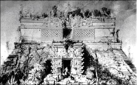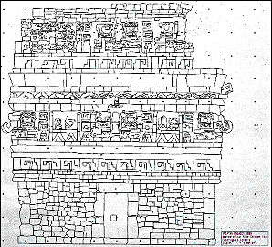
Fig. 1. Uxmal: Adivino Pyramid with Nunnery
Quadrangle (left) (AD 800-1000).
ca 1841. Drawing by Frederick Catherwood.
A historical overview of recording architecture
at the ancient Maya city of Uxmal, Yucatan, Mexico,
1834 to 2007by
Lawrence G. Desmond, Ph.D.
Bibliograhic reference
A historical overview of recording architecture at the ancient Maya city of Uxmal, Yucatan (Mexico), 1834 to 2007.
In, Philippe Della Casa and Elena Mango, eds., Panorama: Imaging ruins of the Greek and Maya worlds. Zurich:
Archaeological Institute, University of Zurich, pp. 6-13. ISBN 978-3-905099-28-7Illustrators and Photographers through the 1860s
The ancient Maya city of Uxmal is located on the Yucatan peninsula of Mexico. The center of the city is a complex of both religious and secular stone buildings that are highly decorated with sculpture, iconography, and hieroglyphics, and dominated by the unique Adivino Pyramid. At its apogee, 1,000 years ago, about 30,000 people lived in the city. In 1996, Uxmal was placed on UNESCOs World Heritage List of Cultural Properties as a site of outstanding universal value. The ruins of the ceremonial structures at Uxmal represent the pinnacle of late Mayan art and architecture in their design, layout and ornamentation.
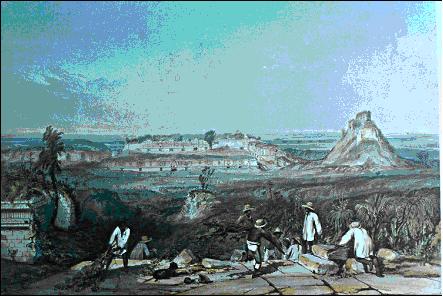
From as early as the 16th century travelers visited the abandoned city of Uxmal, but it was not until the 17th century that a historical account of the city was written by the Spanish scholar Diego Lopez de Cogolludo. In 1834, just before photography came into use, the explorer Jean-Frédéric Waldeck visited Uxmal and made both artistic sketches and careful drawings of a number of the buildings.
Fig. 1. Uxmal: Adivino Pyramid with Nunnery
Quadrangle (left) (AD 800-1000).
ca 1841. Drawing by Frederick Catherwood.
Frederick Catherwood, a superb illustrator, draftsman and architect from London joined with the North American travel writer John Lloyd Stephens in 1839 to explore the Maya ruins in Central America and Mexico. Catherwood used the camera lucida to draw Maya buildings during their expedition to Honduras, Guatemala, and Mexico. He became ill when they arrived at Uxmal, and they returned to New York. In 1841, they returned to Yucatan with a Daguerreotype camera and equipment, and Catherwood attempted to photograph the ruins at Uxmal.
Stephens wrote: we had with us a Daguerreotype apparatus ... with which, immediately on our arrival at Uxmal, Mr. Catherwood began taking views, but the results were not sufficiently perfect to suit us. He then went back to using the camera lucida to draw the Adivino Pyramid and other buildings at Uxmal.
In the 1860s, after the wet collodion glass-plate negative was invented, photographic documentation began to be more widely used by archaeologists and explorers. From the glass negative an unlimited number of prints that could be made, and archaeologists soon learned that they could rapidly capture an enormous amount of architectural detail in a short time. But, photographs captured different information than hand drawn illustrations, and illustrations continued to be used.
One of the earliest photographers to use glass negatives in Yucatan was Désire´ Charnay. He was a French photographer and explorer who in the 1860s documented buildings at a number of Maya sites, including Uxmal, using large format (15 x 21 cm or 30 x 40 cm) negatives. His idea was to use the photographs to illustrate his travel writings.
From the glass plates used by Charnay large contact prints that could be made, and then sold. During the 19th century, he and other expeditionary photographers often funded their archaeological investigations by the sale of photos. Ironically, only a limited number of glass plates could be transported because they were large and fragile, and photographers also had to carry other equipment such as cumbersome cameras, lenses, a tripod, and a darkroom. While each image was carefully crafted, documentation with large numbers of images in the remote tropical forests of Central America was virtually impossible.
It was not until the 1870s that the husband and wife team of Alice Dixon and Augustus Le Plongeon worked out a method for detailed and systematic documentation of the ruins using large numbers of smaller stereo 3D glass-plate negatives. For each large glass plate used by earlier photographers, five times as many photos could be taken, and their method made thorough photographic documentation of archaeological sites in the remote forests of Yucatan feasible.
A new approach: Alice Dixon and Augustus Le Plongeon at Uxmal
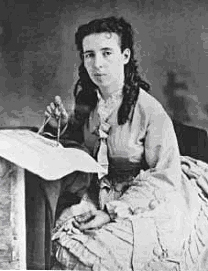
Alice Dixon (18511910) was born and schooled in London. She learned architectural photography from her father Henry Dixon who received many awards and commissions to documented historic buildings in London. She used her training to photograph the ruins of Uxmal and other Maya cities in Yucatan in the 1870s and 1880s.
Figures 3 and 4. Augustus Le Plongeon, ca 1873, and Alice Dixon Le Plongeon, ca 1873.
Photos by Alice Dixon Le Plongeon and Augustus Le Plongeon. Peabody Museum, Harvard University, Photo P2500B and P2501B.Alice was a master photo printer, she published articles on photographic methods, and 2,400 of her prints of the Maya ruins are currently in public and private collections. After 1884, she and her archaeologist husband, Augustus Le Plongeon, lived in New York where Alice lectured, and wrote for popular and professional journals on the history of the Maya, and photography.
Augustus Le Plongeon (18261908) was born on the Island of Jersey, and came to San Francisco during the California Gold Rush. While he was in England in 1851, he was taught photography by the great photographer Fox Talbot. In 1862, Augustus moved to Lima, Peru where he used the wet collodion glass-plate negative process to record buildings at archaeological sites.
Alice and Augustus systematically photographed Maya buildings with hundreds of stereo photographs. Their use of small 4 x 8 inch glass plates for stereo 3D photography was a major change from the methods of their predecessors. They also devised a small portable darkroom where all their photographic paraphernalia could be easily packed to protect it during their travels over he rough roads of Yucatan.
At Uxmal, the Le Plongeons lived in the large center room of the ruined, but magnificent, Maya Governors Palace. The location of their darkroom had to be frequently changed as they photographed different buildings. To photograph the buildings at Uxmal using wet collodion glass plates required preparation of a plate just minutes before exposure. A thick solution of clear collodion was spread over the glass plate, then it was sensitized by dipping it into silver nitrate. The plate was then placed in a light-tight plate holder, and rushed to the camera atop a tall ladder to be exposed before the collodion dried. After exposure the plate had to be immediately developed and fixed. To make matters even more difficult, clouds could ruin an exposure, and the photo chemicals were often impure thus requiring a number of tests before they could be used.
The Le Plongeons started by systematically photographing the entire 320 ft east façade of the Governors Palace with 16 overlapping stereo photographs on 4 x 8 inch plates. All the photos were taken at the same distance and height. The work may have taken as much as two weeks because the angle of the sun to highlight the intricate motifs was correct for only a few hours each day.
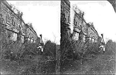
Figure 5. Stereo photograph of Augustus Le Plongeon photographing the east façade of the Governor's Palace, Uxmal (AD 800-1000).
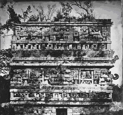
Photograph and print by Alice Dixon Le Plongeon, ca 1875. Peabody Museum, Harvard University, Photo PM59-50A.After the Governors Palace, they began the difficult and dangerous task of recording the west façade of the Adivino Pyramidabout 60 feet above the ground. To photograph the bas relief iconography on the temple, Augustus climbed a tall handmade ladder-tripod on which he mounted his camera for undistorted views. Alice took charge of the darkroom work, prepared the negatives and printed them. Their hundreds of photographs of Maya buildings are today an important record that is used for analysis and conservation.
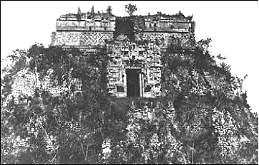
Figure 6. The Chenes Temple and upper Puuc Temple on the west façade of the Adivino Pyramid, Uxmal (AD 800-1000).
Photograph by Augustus Le Plongeon, (ca 1875, print by Alice Dixon Le Plongeon. Peabody Museum, Harvard University, Photo P2506A.
Documentation comes of age at Uxmal: the 20th Century
As the 19th century came to an end, archaeologist Alfred P. Maudslay made a superb photographic record of the iconography and architecture of buildings at Uxmal. During this same period, the Austrian, Teobert Maler, carried out photographic documentation at the site for the Peabody Museum at Harvard University.
By the 1930s, Mexican scholars such as Manuel Gamio, Alfonso Caso, and Jimenez Moreno had established a single national organization to protect and conserve the entire archaeological and historical heritage of Mexico. After its inception, the National Institute of Anthropology and History (INAH) initiated a number of conservation and documentation projects at Uxmal.
In the 1930s, archaeologist Frans Blom of Tulane University led an expedition that photographed and made molds of the entire Nunnery Quadrangle. Archaeologist and epigrapher Ian Graham with the Peabody Museum at Harvard University, realized the usefulness of stereo 3D photography for recording hieroglyphics, and documented carved Maya glyphs at Uxmal, and at numerous other sites in the Maya area of Mesoamerica.
Since the early 1960s, archaeologist Merle Greene Robertson set a high standard for documentation of architecture at Uxmal and other Maya sites by using photography, rubbings, and scaled drawings of buildings. For her achievement in recording architecture the president of Mexico honored her with the Order of the Aztec Eagle which is the highest award given to a non-Mexican citizen.
Archaeologist Alfredo Barrera R., with INAH, has worked at Uxmal since the 1970s to map and photograph the site, and to conserve the architecture as has site archaeologist José Huchim H. In the 1980s, art historian Jeff K. Kowalski documented the iconography and architecture of the Governors Palace with photos and made measured drawings of the facade.
With the exception of the Le Plongeons and Graham, New World archaeological documentation used only 2D photography well into the 1980s, but stereo 3D imaging would soon be used. In 1988, a severe hurricane caused structural destabilization of the west façade of the Adivino pyramid, and it was in danger of collapse.

Figures 7 and 8. Adivino Pyramid (AD 800-1000), west façade, Uxmal. Drawing by John Garcia, scale: 1:150 with cracks in façade,1989.
Photo taken with a calibrated camera, and image used to make photogrammetric drawing. By Lawrence G. Desmond,1989.Shortly after the hurricane, archaeologist Lawrence Desmond was in Yucatan to test the use of photogrammetric equipment, and the director of INAH asked him to document the façade. Documentation was made from the ground in stereo 3D with a calibrated photogrammetric camera, and surveyed using an analog theodolite. After the fieldwork, photogrammetrist John Garcia made a 1:150 scale drawing of the west façade useful for reconstruction should façade have collapsed. To enhance the photographic and survey data of the pyramid, Desmond returned to Uxmal in 1990 with civil engineering professor Gerald Johnson to take additional photos, and used a small hydrogen balloon to photograph the upper level Chenes Temple. The pyramid was surveyed with greater accuracy using a digital total station theodolite.
Measured drawings of Maya buildings can also be made from the 3D photos taken by the Le Plongeons. To demonstrate this technique, the Le Plongeon photo of a small building with a damaged roof comb at the nearby Maya site of Chichen Itza was calibrated from recent photogrammetric photos. The building was then drawn as it looked in the 1870s.
Figures 8 and 9. La Iglesia building (AD 800-1100), Chichen Itza.
Collapsed upper right corner (red) has been restored to scale using calibrated 3D Le Plongeon photo (right).
Drawing by John Garcia, 1990. Photo of La Iglesia by Augustus Le Plongeon (1/2 of stereo pair), ca 1873.
Peabody Museum, Harvard University, Photo P2509B.
Figures 10 and 11. La Iglesia building (AD 800-1100), Chichen Itza.
The building was drawn using a 3D Le Plongeon photo calibrated photogrammetrically with the 3D photo on the right.
Photo by L. G. Desmond is one photo of a stereo pair, 1989. Drawing by John Garcia,1990.
The whole Adivino Pyramid recorded, and 21st century technology
Late in 1997, archaeologists at Uxmal noted that more cracks had developed in the walls of the pyramid in spite of work by INAH archaeologists to stabilize the pyramid. The Adivino Pyramid Conservation Project was then initiated as a joint project of the University of Yucatan and INAH, and stereo 3D photogrammetric recording was recommended by the committee of archaeologists and engineers. Engineers planned to monitor any movement, and study the pyramid using the 3D photographs and survey data. Because the entire pyramid was to be recorded, Desmond was asked to organize a professional team of photogrammetrists to work with the Mexican archaeologists and engineers.
Paul Bryan and Michael Clowes, with English Heritages Metric Survey Team, were contacted because of their international reputation as photogrammetrists and surveyors. They immediately realized the challenge and importance of the project, and agreed to come to Uxmal during their vacation days. To take the photos, a Rollei 6006 medium format (6 x 6 cm) calibrated photogrammetric camera, with a 50 mm lens was used. The film was color Kodak Professional Ektachrome, and for an archival backup, black-and-white Kodak Verichome Pan. A Nikon DTM 310 total station theodolite, loaned by a professional surveyor in Yucatan, was used to collect three dimensional data from targets placed on the pyramid, and the secondary survey monuments.
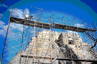
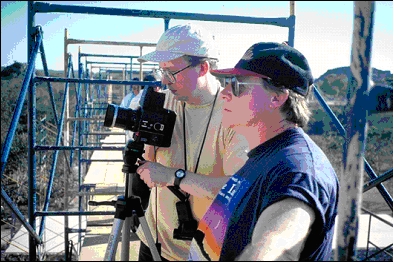
Figure 12. Scaffolding for photographing the upper part of the west façade of the Adivino Pyramid. 1999.
Bryan and Clowes are photographing at the 14 meter level. Photograph by Lawrence G. Desmond.The endangered west façade was photographed from the ground, and from a scaffold at two levels above the ground. The remainder of the pyramid was photographed by Bryan and Clowes from a bucket at the end of the long arm of a hydraulic lift. More than 700 photographs in color and black-and-white were taken.
After the color transparencies were developed, they were all scanned using Kodaks PRO Photo-CDTM system. For each image this produced computer files of approximately 50 Mb each, with a resolution of around 1200 dpi. Measured drawings of any part of the pyramid can now be prepared whenever required. As a first step, digital images of the west façade of the Chenes Temple were processed, using a Leica Helava DPW, to create a measurable orthophotograph.
Figure 13. Mick Clowes (R), and Paul Bryan (L), photographing the west façade of the Adivino Pyramid
from scaffolding at 14 meters. 1999. Photo by Lawrence G. Desmond.
The technology for the documentation of architecture has changed significantly over the past 150 years, but the reasons for recording architecture remain much the same. Recording is done to mitigate the impact of the natural environment and human intervention, and to understand the meaning of an ancient civilization through its architecture. In addition, today UNESCOs Charter of Venice mandates photogrammetric documentation of World Heritage Sites, and conservation planning and structural analysis often require precise survey data of a building.
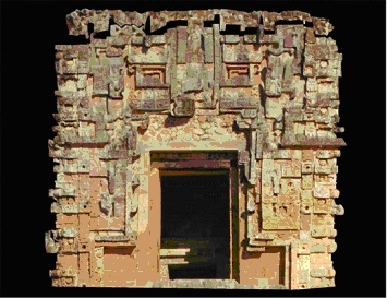
Figure 14. Orthophotograph of the Chenes Temple (AD 800-1000) on the west side of the Adivino Pyramid
from which scaled drawings can be made. 1999. Orthophotograph by Michael Clowes.Since the 1999 project, there have been significant advances in digital imaging and its application to photogrammetry because of greatly increased computing power. Those advances have made precise recording of historic architecture more accessible to persons minimally trained in photogrammetic documentation, and consequently increased the number of important monuments that have been recorded.
The next generation of architectural recording technology to be applied at Maya archaeological sites will be high resolution 3D laser scanning. The laser images of ancient buildings are in real time, and can be manipulated for the analytical requirements of archaeologists, art historians, and conservators, or for the public interested an entertaining fly through of an ancient Maya temple.